Laya Road Closure After Sintaphu GLOF: Trekker Update
By Best of Bhutan Research Desk · November 4, 2026 · 8 min read
Update, 5 November 2026: The artificial lake that formed behind flood debris at Taktsemakhang is reported stable, with no rise in water level and a constant outflow, according to The Bhutanese. Prime Minister Tshering Tobgay inspected the site and said it was not very dangerous. The Gasa administration plans to drain it with an excavator, and controlled blasting is being considered, but work is held up because the Punakha–Gasa road is cut and no fuel can reach the site. The NCHM ground assessment of the Sintaphu lakes themselves has not been reported yet, and no reopening date has been given for the Laya road. Details are in the artificial lake section below.
The Laya road closure caused by the Sintaphu glacial lake outburst is worse than first reported. On 2 November 2026, Kuensel reported that floods had blocked three major sections of the Laya Gewog Centre road between Koina and Tongchudra, and that the Tongchudra bridge had been washed away completely. The same day, BBS reported that satellite analysis suggests the flood began with an outburst from an upper lake above Sintaphu, and that a substantial volume of water is still held there.
This post is an update to our Sintaphu GLOF 3D flood model, published on 30 October, the day after the outburst. That post covers the flood itself, Gasa Tsachu and the Punakha–Gasa highway. This one covers what has been reported since, and what it means if you are planning a trek in Gasa.
Key Facts at a Glance
| Detail | What has been reported |
|---|---|
| Event | Glacial lake outburst flood (GLOF) from Sintaphu (Shintaphu) Tsho, Laya Gewog, Gasa |
| Tongchudra bridge | Washed away completely |
| Human casualties | None reported |
| Date of outburst | Evening of Thursday 29 October 2026 |
| Likely trigger | Outburst from the upper of the two Sintaphu lakes, based on satellite data (preliminary) |
| Water lost | Lower lake about 80% of its volume; upper lake about 10% (ICIMOD specialist, via BBS) |
| Laya road | Three major sections blocked between Koina and Tongchudra |
| Livestock | At least 128 yaks and 12 horses suspected dead; preliminary loss Nu 6.8 million (Department of Livestock, via Kuensel) |
| Gasa Tsachu | Hot spring facilities washed away on 29 October |
| Artificial lake (Taktsemakhang) | Stable, no rise in water level, constant outflow; monitored on site; drainage planned but stalled for lack of fuel (The Bhutanese) |
| Ground assessment | NCHM team waiting for a helicopter; findings so far are from remote sensing |
| Reported by | BBS and Kuensel, 2 November 2026; Kuensel, 4 November 2026; The Bhutanese, early November 2026 |
What Changed Since the First Reports
The upper lake probably started it
Sintaphu is not one lake but two. According to BBS, the National Centre for Hydrology and Meteorology (NCHM) says the lower lake holds more water. BBS put the two lakes together at roughly 3,200 Olympic swimming pools of water, and said the flood released close to 2,000 of them, about 60% of the combined volume.
BBS quoted Dr Sonam Wangchuk, a cryosphere specialist at the International Centre for Integrated Mountain Development (ICIMOD), on the satellite analysis. His estimate is that the lower lake lost about 80% of its volume and the upper lake about 10%. That points to a chain reaction: the upper lake burst first and pushed water into the lower lake, which then failed. Kuensel reported the same preliminary finding on 4 November.
Early reports on 30 October said the cause had not been confirmed (Climate Fact Checks). The upper-lake explanation is still preliminary. It has not been checked on the ground.
Water is still held in the upper lake
The upper lake lost only a small share of its water. BBS reported that a substantial volume remains in it. Sintaphu is one of the 17 glacial lakes Bhutan classes as potentially dangerous, so the authorities will want to see it in person before calling the area safe.
The artificial lake at Taktsemakhang is stable for now
After the outburst, a lake formed behind flood debris at the confluence of the Shintaphu Chhu and Lungu Chhu at Taktsemakhang (BBS spells it Taktsi Makhang). On 30 October NCHM issued an advisory about it.
The latest report, from The Bhutanese, says:
- The lake is stable. Officials have seen no noticeable rise in water level, and water is flowing out at a constant rate.
- The Gasa disaster management office has posted a person at the site to watch it around the clock. NCHM tracks the Mo Chhu at its Tashithang and Yebesa stations.
- Prime Minister Tshering Tobgay visited Taktsemakhang and said the lake was not very dangerous.
- The Gasa Dzongkhag administration plans to drain the lake with an excavator, and controlled blasting downstream is being considered. The work has not started because the only road from Punakha to Gasa is cut, so fuel cannot get through.
Stable is not the same as safe. The lake is still held by loose debris, and the authorities have not said when it will be drained. In our earlier post we modelled what a breach of a debris dam at this point could do downstream.
The ground team has not reached the site yet
NCHM Director General Karma Dupchu told BBS the agency was "waiting for helicopter availability" to send a post-flood assessment team. Everything known so far about the lakes comes from satellite images. Communities along the Mo Chhu have been asked to stay alert. As of 5 November we have not found a published report of the ground assessment.
The Laya Road and the Tongchudra Bridge
The first wire reports, carried by Al Jazeera from Reuters on 30 October, said part of the road to Laya was impassable and cited Kuensel saying it was closed to traffic indefinitely.
Kuensel's 2 November report gives more detail:
- Three major sections of the Laya Gewog Centre road are blocked between Koina and Tongchudra.
- The Tongchudra bridge has been completely washed away.
Kuensel did not give a date for reopening the road or replacing the bridge in the part of the report we could access. We have not found an official repair timeline. Treat the road as closed until the Gasa Dzongkhag administration or the Department of Surface Transport says otherwise.
The Punakha–Gasa highway was also damaged. On 30 October a section near km 31.85 was reported lost and the road closed until further notice (Climate Fact Checks). We have not seen a reopening announcement.
Laya's Herders Lost at Least 128 Yaks
Laya is a highland community that depends on yaks. On 2 November, Kuensel reported that at least 128 yaks and 12 horses are suspected to have died in the flood. The Department of Livestock put preliminary losses at Nu 6.8 million.
No people were hurt; the area was evacuated before the water arrived (Climate Fact Checks). But for the herding families, the loss of animals is a serious economic blow. Kuensel's 4 November feature on climate and biodiversity also noted damage to farmland and infrastructure.
For background on how herding works in the north, see our post on National Yak Day and Bhutan's herders.
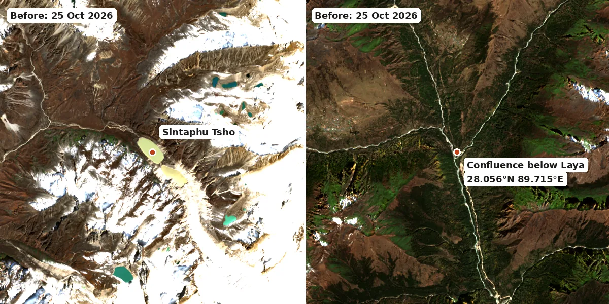
Before the outburst, 25 October 2026. Contains modified Copernicus Sentinel data 2026.
What This Means for Travellers
Laya trek
The Laya trek depends on the road from Gasa and on the trails and bridges in the Mo Chhu valley. With three road sections blocked, a key bridge gone and the flood channel not yet assessed on the ground, do not assume a Laya departure will run as planned this season.
If you are booked:
- Ask your tour operator whether your route uses the Koina–Tongchudra stretch or the Tongchudra bridge, and what the alternative is.
- Ask whether campsites near the river have been checked.
- Ask how pack animals are being arranged. Herders in Laya have just lost animals, and treks in the north rely on horses and yaks to carry gear.
- Get the change and cancellation terms in writing.
Snowman trek
The Snowman trek passes through Laya on many itineraries. The same questions apply. It is also the hardest trek in Bhutan, and any extra days lost to detours add to the altitude risk. Our complete trekking guide covers seasons, permits and acclimatisation.
Gasa Tsachu hot springs
The Gasa Tsachu facilities were washed away on 29 October (Al Jazeera/Reuters). They were also hit by a flash flood in 2021. There is no reopening date. Do not plan a visit until the Gasa Dzongkhag administration reopens the site.
Punakha and the Mo Chhu valley
After the outburst, Punakha Dzong was closed to the public as a precaution, and residents of the Mo Chhu and Punatsangchhu valleys were told to avoid the riverbanks (Al Jazeera/Reuters). Downstream, the Punatsangchhu-II hydropower project shut its generating units and opened its dam gates as a precaution on the night of the flood (Eastern Lens). Wangdue Dzongkhag has asked people not to collect or eat dead or stranded fish from the river (The Bhutanese). We have not confirmed whether the dzong has reopened. Ask your guide before you go, and stay away from the riverbanks until NCHM lifts its advice. See our Punakha guide and our Bhutan travel restrictions guide for other closures.
If you want a high trek this season instead
Treks in the Paro and Thimphu valleys are outside the Mo Chhu flood path. The Druk Path trek between Paro and Thimphu and the Jomolhari base camp trek are the usual alternatives. Check current trail conditions with your operator before switching.
How to Check the Latest Status
- Flood warnings and lake status: the National Centre for Hydrology and Meteorology (NCHM) is the official source.
- Road status: the Department of Surface Transport and the Gasa Dzongkhag administration.
- News: BBS and Kuensel have reported each development since 29 October.
- Your operator: a licensed Bhutanese tour operator will have the most current information on trail access and pack animals.
Frequently Asked Questions
Is the Laya road open?
No. As of 2 November 2026, Kuensel reported three major sections blocked between Koina and Tongchudra and the Tongchudra bridge washed away. No reopening date has been announced.
Can I still do the Laya trek in 2026?
It depends on the route your operator uses and how fast the road and bridge are repaired. Until the authorities confirm access and the post-flood assessment is done, ask your operator for a written plan and an alternative such as the Druk Path or Jomolhari trek.
What caused the Sintaphu GLOF?
Preliminary satellite analysis reported by BBS and Kuensel suggests an outburst from the upper of the two Sintaphu lakes pushed water into the lower lake, which then released most of its volume. This has not yet been verified on the ground.
Is there still a flood risk in Gasa and Punakha?
Officials have not said the danger is over. A substantial volume of water remains in the upper Sintaphu lake. The artificial lake at Taktsemakhang is reported stable with a constant outflow, but it has not been drained yet. Communities along the Mo Chhu and Punatsangchhu were asked to stay alert and avoid riverbanks. Follow NCHM warnings.
Is Gasa Tsachu hot spring open?
No. The facilities were washed away on 29 October 2026. Check with the Gasa Dzongkhag administration before planning a visit.
Related Reading
- Sintaphu GLOF 3D flood model: Gasa to Punakha
- Thorthormi Lake glacial flood siphon test
- Royal Highland Festival in Laya
- Gasa destination guide
Sources
- BBS: Shintaphu GLOF may have been triggered by outburst from upper lake, 2 November 2026
- The Bhutanese: Gasa artificial lake stable, no rise in water level reported, early November 2026
- Kuensel: Laya road severely damaged, Tongchudra bridge washed away, 2 November 2026
- Kuensel: Shingtaphu lake outburst kills 128 yaks, 12 horses, 2 November 2026
- Kuensel: Sintaphu Lake has emptied, but has the danger passed?, 4 November 2026
- Kuensel: From Yerevan to Laya, climate and biodiversity crises collide, 4 November 2026
- Al Jazeera (Reuters): Bhutan hot springs hit by flood from glacial lake burst, 30 October 2026
- Eastern Lens: Bhutan Shintaphu Lake Flood, Laya Cut Off, 30 October 2026
- ICIMOD: Bhutan GLOF triggers downstream alerts, 30 October 2026
- Climate Fact Checks: A Quiet Lake, a Loud Night, 30 October 2026