Sintaphu GLOF 3D Flood Model: Gasa to Punakha
By Best of Bhutan Research Desk · October 30, 2026 · 10 min read
Sintaphu Tsho, a moraine-dammed glacial lake at the head of the Mo Chhu in Gasa, burst on the evening of Thursday 29 October 2026. The Sintaphu GLOF (glacial lake outburst flood) washed away the Gasa Tsachu hot spring facilities, cut the road to Laya and sent a flood wave down the Mo Chhu towards Punakha. No deaths or injuries were reported, Reuters reported citing BBS. Kuensel said the area had been evacuated before the water arrived.
We wanted to see how the flood moved through the valley, so we built a model of it. It uses open satellite terrain data and the figures reported so far. The 3D model below lets you play the flood wave from the lake to Wangdue Phodrang. It also has a second scenario: a breach of the debris-dammed lake reported below Laya.
Important: this is an independent screening estimate, not an official forecast. For warnings and road status, follow the National Centre for Hydrology and Meteorology (NCHM), the Gasa and Punakha Dzongkhag administrations and the Department of Surface Transport.
Drag to orbit, scroll or pinch to zoom, right-drag (or two fingers) to pan. Press play, or click a place label to see its modelled flow. Terrain: Copernicus GLO-30 DEM. Imagery: contains modified Copernicus Sentinel data 2026 (pre-event, 17–25 October); cloud-covered areas are filled with shaded relief.
Key Facts at a Glance
| Detail | What has been reported or modelled |
|---|---|
| Lake | Sintaphu (Shintaphu) Tsho, Lungo, Laya Gewog, Gasa |
| Lake elevation | About 4,480 m (2021 study) |
| When | Evening of 29 October 2026 |
| Water released | About 7.4 million m³ (preliminary, Business Today); still under assessment, ICIMOD says |
| First gauge | Flood passed Taktsemakhang at about 8:15–8:27 pm |
| Damage | Gasa Tsachu facilities washed away; Punakha–Gasa highway lost near km 31.85; road to Laya closed; two Bailey bridges possibly lost |
| Casualties | None reported |
| Modelled peak at Taktsemakhang | About 4,100 m³/s (range 2,300–6,600) |
| Modelled peak at Punakha Dzong | About 700 m³/s, roughly 5 hours after the breach (range 490–1,060 m³/s, 3.5–7.5 hours) |
| Second hazard | A "large artificial lake" reported below Laya after the outburst |
What Happened on 29 October
Sintaphu Tsho sits near Wakila mountain in Lungo, Laya Gewog. It is one of Bhutan's potentially dangerous glacial lakes, and specialists surveyed it in May and June 2023, according to The Tribune (ANI). A 2021 study in Applied Sciences measured it at about 238,000 m² and 6.2 million m³. Before the outburst, ICIMOD put the volume at 6–7 million m³.
Here is what has been reported so far:
- The flood reached Taktsemakhang, the first NCHM water-level station below Laya, at about 8:15 pm (The Tribune/ANI). NDTV Profit put the crossing at 8:27 pm (EconoTimes). It later passed Srigang in Kabesa, about 8 km from Punakha Dzong.
- The Gasa Tsachu complex beside the Mo Chhu was washed away. So was a section of the Punakha–Gasa highway near km 31.85, which is closed until further notice.
- BBS said two Bailey bridges may have been lost, and that darkness and the strong flow made the damage hard to assess (Al Jazeera/Reuters).
- Punatsangchhu II hydropower plant stopped generating and opened its spillway gates (Climate Fact Checks).
- The Punakha Dzongkhag administration closed Punakha Dzong to the public as a precaution, according to an Al Jazeera photo caption.
- In India, the Central Water Commission issued an advisory for Alipurduar and Dhubri districts. Residents along the Sankosh were moved to relief camps (LatestLY).
ICIMOD Director General Pema Gyamtsho said Bhutan's timely warnings "demonstrate the value of sustained monitoring".
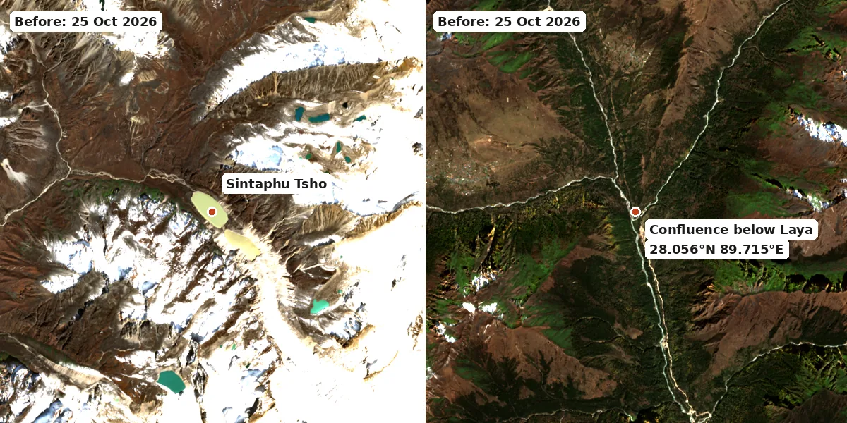
Before the outburst, 25 October 2026. Contains modified Copernicus Sentinel data 2026. No clear post-event image was available on 30 October because of cloud.
How We Built the Flood Model
The model is a standard screening approach for glacial lake outbursts. It runs in three steps.
- Terrain. We used the Copernicus GLO-30 elevation model (30 m) and traced the flow path from the lake down the Mo Chhu. Every 200 m along that path we cut a cross-section across the valley, 540 sections in all. Each one tells the model how wide and deep the valley is at different water levels.
- Breach. We modelled the moraine eroding into a trapezoidal breach using the widely used Froehlich equations, releasing 7.4 million m³. Breach depth is the biggest unknown, so we ran 20 m, 30 m and 40 m. These give peak outflows from the lake of about 2,700, 5,000 and 7,500 m³/s.
- Routing. We routed the flood down the valley with a one-dimensional diffusion-wave model. It conserves water volume and lets the wave spread out and slow down in wider reaches. We tested three channel roughness values (Manning n 0.04, 0.06 and 0.08), giving nine runs in total. The central run uses a 30 m breach and n = 0.06.
We assumed a late-October base flow of about 0.03 m³/s per km² of catchment. That gives about 40 m³/s at Punakha.
Results: When the Flood Reached Each Place
Times are hours:minutes after the breach. Clock times are approximate. The central run takes 54 minutes to reach Taktsemakhang, so matching the reported 8:15–8:27 pm crossing puts the breach at roughly 7:20–7:35 pm. NCHM has not confirmed the time of the breach.
| Place | km below lake | Arrives → peaks (central) | Peak flow, central (range) | Level rise, central (range) |
|---|---|---|---|---|
| Taktsemakhang gauge (approx.) | ~20 | 0:54 (~8:19 pm) → 0:58 | 4,100 m³/s (2,300–6,600) | 7.6 m (4.6–10.3) |
| Confluence below Laya | 22 | 0:58 → 1:00 | 4,100 m³/s (2,250–6,400) | 6.1 m (4.1–7.9) |
| Koina | 32 | 1:16 → 1:22 | 3,000 m³/s (1,600–4,900) | 5.4 m (3.5–6.2) |
| Gasa Tsachu | 46 | 1:44 (~9:09 pm) → 1:46 | 2,450 m³/s (1,350–3,950) | 4.1 m (2.8–4.8) |
| Punakha Dzong | 90 | 4:36 (~midnight) → 5:10 (~12:35 am) | 710 m³/s (490–1,060) | 3.7 m (3.2–3.9) |
| Wangdue Phodrang | 104 | 6:30 → 7:54 | 470 m³/s | 2.7 m |
Ranges cover the nine breach and roughness runs. At Wangdue the slowest runs had not peaked by the 9-hour cut-off, so only the central run is shown.
Three things stand out:
- The flood weakened by about 85% between the lake and Punakha. A peak of about 5,000 m³/s at the breach fell to about 700 m³/s at Punakha. The wave spread out in the wider sections of the valley below Gasa. That matches the 2021 study of this lake, which modelled up to 950 m³/s at Punakha from a slightly smaller volume.
- The timing matches NCHM's own planning figure. NCHM's GLOF early warning procedure puts Taktsemakhang about 70 km above Punakha Dzong and expects a flood to take about 3–4 hours between them. Our central run takes about 4 hours 10 minutes from peak to peak.
- The gauge would have passed alarm level. The same procedure sets the Taktsemakhang alarm stage at 8.5 m. A modelled rise of 5–10 m on top of normal river level fits the sirens that were reported along the Mo Chhu and Punatsangchhu.
The Second Hazard: A Debris-Dammed Lake Below Laya
After the outburst, Kuensel reported concern about a "large artificial lake" that formed where flood-affected channels merged (Al Jazeera). Tenzing Lamsang, editor of The Bhutanese, also posted that an artificial lake had formed upstream. NCHM had not published its size when we checked.
The terrain shows why this spot is vulnerable. At 28.056°N, 89.715°E, just below Laya, the Sintaphu flood channel (draining about 209 km²) meets streams from the Laya side (about 185 km²). If flood debris blocked the confluence, water from those other streams would back up behind it.
We measured how much water a dam at the confluence could hold, using the pre-flood terrain:
| Dam height | Water stored | Lake area | Lake length |
|---|---|---|---|
| 10 m | 0.10 million m³ | 2.4 ha | ~0.3 km |
| 20 m | 0.48 million m³ | 5.6 ha | ~0.5 km |
| 25 m | 0.81 million m³ | 7.6 ha | ~0.6 km |
| 30 m | 1.27 million m³ | 10.3 ha | ~0.8 km |
| 40 m | 2.70 million m³ | 17.8 ha | ~1.0 km |
| 50 m | 4.86 million m³ | 26.0 ha | ~1.1 km |
The valley is steep there (about 5%), so even a tall dam holds a short lake. We then modelled the dam failing at three heights:
| Dam height | Peak outflow | Koina | Gasa Tsachu | Punakha Dzong |
|---|---|---|---|---|
| 15 m | ~610 m³/s | +0.7 m | +0.4 m | negligible |
| 25 m | ~1,830 m³/s | +1.9 m after 0:34 | +1.0 m after 1:34 | +0.7 m after ~8 h |
| 40 m | ~5,600 m³/s | +5.1 m after 0:26 | +2.9 m after 0:56 | +2.0 m after 5:16 |
In this model, a debris dam lower than about 25 m would mostly be a local hazard between Laya and Gasa. A dam of 40 m or more would send a flood comparable to the original wave as far as Gasa Tsachu. We do not know the real dam height. The flood deposits have also changed the valley since the terrain data was captured. Treat these numbers as a guide to scale only.
Limits of This Model
- It is one-dimensional. It assumes water spreads evenly across each cross-section. A two-dimensional model such as HEC-RAS, which the 2021 study used, handles bends, side channels and backwater better.
- Clear water only. A real outburst carries huge amounts of sediment and boulders. That can raise peaks locally, block channels (as below Laya) and cause erosion the model cannot show.
- 30 m terrain data. It cannot resolve narrow gorges, bridges or buildings. In the 3D view, channels narrower than 170 m are drawn wider so they stay visible.
- Unknown breach. The real breach depth, how fast it formed and how much water left are not yet published. The range of runs reflects that uncertainty.
- Model domain. The model stops at Wangdue Phodrang. It does not cover the Punatsangchhu dams or the Sankosh in India.
What This Means for Travellers
- Punakha–Gasa road: closed near km 31.85 until further notice. Check with the Department of Surface Transport before travelling north of Punakha.
- Gasa Tsachu: the hot spring facilities were washed away. Do not plan a visit until the Dzongkhag reopens the site. See our Gasa destination page for the wider area.
- Laya and the northern treks: the road to Laya is closed. If you are booked on the Laya trek or the Snowman trek, ask your operator about the route and timing. Events such as the Royal Highland Festival in Laya depend on this access.
- Punakha: Punakha Dzong was closed to the public as a precaution after the outburst. Ask your guide whether it has reopened and stay away from the riverbanks of the Mo Chhu and Punatsangchhu until the authorities say otherwise. Our Punakha guide has alternatives nearby.
- Bhutan's glacial lakes: for background on another lake that NCHM watches closely, read our report on the Thorthormi Lake siphon test.
Frequently Asked Questions
What is the Sintaphu GLOF?
It is the glacial lake outburst flood from Sintaphu (Shintaphu) Tsho in Laya Gewog, Gasa, on the evening of 29 October 2026. About 7.4 million m³ of water was reported released (preliminary). It flooded the Mo Chhu, washed away Gasa Tsachu's facilities and damaged the Punakha–Gasa highway. No casualties were reported.
How long did the Sintaphu flood take to reach Punakha?
Our central model run puts the peak at Punakha Dzong about 5 hours after the breach, with a range of 3.5 to 7.5 hours. NCHM's own planning figure is 3–4 hours from the Taktsemakhang gauge to Punakha Dzong.
Is Gasa Tsachu hot spring open?
No. The facilities beside the river were washed away on 29 October 2026. Check with the Gasa Dzongkhag administration before planning a visit.
Is there still a flood risk below Laya?
Kuensel reported a large artificial lake after the outburst. If a debris dam fails, our model shows the risk depends mostly on its height. A dam under 25 m would cause mainly local flooding between Laya and Gasa. A dam of 40 m or more could send a significant flood to Gasa Tsachu. Follow NCHM warnings.
Is this an official forecast?
No. It is an independent screening model built from open satellite data and published reports. NCHM is the official source for flood warnings in Bhutan.
Sources
- Reuters via The Kathmandu Post and Al Jazeera, citing BBS and Kuensel, 30 October 2026
- The Tribune (ANI), 30 October 2026
- EconoTimes, citing NCHM and NDTV Profit, 30 October 2026
- Business Today, 30 October 2026
- Climate Fact Checks, 30 October 2026
- ICIMOD press release, 30 October 2026
- LatestLY, 30 October 2026
- NCHM, Standard Operating Procedure for GLOF Early Warning System
- Hazard Assessment for a Glacier Lake Outburst Flood in the Mo Chu River Basin, Bhutan, Applied Sciences 11(20), 9463 (2021)
- Terrain: Copernicus GLO-30 DEM, © DLR e.V. 2010–2014 and © Airbus Defence and Space GmbH 2014–2018, provided under COPERNICUS by the European Union and ESA
- Imagery: contains modified Copernicus Sentinel data 2026